Design. Refine. Filter. FilterWizard® → LAUNCH NOW!

teamSOIGNE®
User interface suite distinguished for its ease-of-use, data manipulation and effective visualization tools
teamSOIGNE®
Robust signal mining, analysis and monitoring tools for Espy’s teamSENTINEL® wideband recording RF sensors.
The teamSOIGNE Client Application Suite is distinguished for its ease-of-use and effectiveness. Highly optimized around typical signal mining and signal development workflow, all applications share common GUIs which provide rapid access to signals of interest stored on a teamSENTINEL® sensor with a minimum of menu and mouse clicks.
With over 20 years of experience in optimizing GUI's for customer workflows, our GUI's are recognized for their ability to intuitively present hundreds of terabytes of RF data visually and interactively across wide area networks. Our GUI's present a well-recognized and respected common operational picture (COP) across all its teamSENTINEL hardware serving as the customer communities preferred signal mining toolkit for signal search, discovery and analysis.
TeamSOIGNE client software application suite runs on high-end commercial workstations. Advanced data-management and compression algorithms developed by MPG Espy ensure that teamSOIGNE operators experience rapid screen updates, even across low-bandwidth/high-latency network connections so often encountered in remote operational environments. Collaboration between distributed operators is intrinsic and intuitive, allowing close coordination and minimal overlap between mission elements working together side-by-side or remotely.
Find Products Request Commercial Price List
Capabilities
Remotely access and analyze terabytes of recorded digital RF by teamSENTINEL wideband sensors. Interactively view, search, interrogate, geolocate, and analyze emitters of any modulation scheme or bandwidth with integrated spectrum, RF/ML list and globe GUIs. Simultaneously access and task multiple networked connected teamSENTINEL sensors from anywhere in the world with highly adaptive resolution displays.
Featured Brand
tsSpectrum
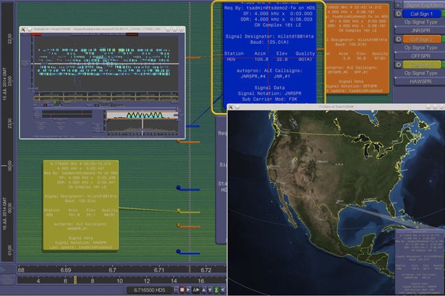
Interactively search, locate, correlate, and analyze signals of interest from a satellite view.
tsSpectrum provides a satellite view for the volumes data collected by teamSENTINEL. With tsSpectrum, analysts can visually search the entire recorded RF spectrum to locate and identify new signal transmissions of interest. Analysts can filter Signal of Interest results using QuickAssist generated metadata signal parameters such as signal type, bandwidth, duration, azimuth, fix, etc. Transmissions can be further characterized by extracting narrowband files for a variety of signals characteristics, including audio, spectral, DF, signal recognition and demodulation.
Using our teamVIEW capability built into tsSpectrum, individual teamSOIGNE analyst workstations can be configured to coherently display spectral data side-by-side from networks of teamSENTINEL sensors. Using side-by-side comparisons, an analyst can manually confirm that a transmission collected at one location matches some or all the transmissions received at other locations. Locations that experienced some form of co-channel interference for a Signal of Interest can be removed from the sensor team prior to collecting DDR's of the transmission or attempting to geolocate the signal. TeamVIEW can also be utilized to access fixed-azimuth sonogram beams on N-channel super resolution sensors.
tsAnalyzer
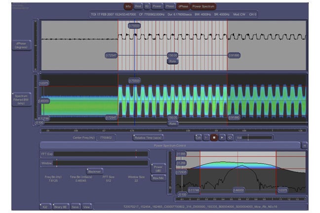
Examine, measure, and analyze waveform characteristics of a high-resolution time domain sample file.
tsAnalyzer is the signal waveform microscope of the teamSOIGNE signal mining tool kit. Using tsAnalyzer, analysts can examine, measure and analyze waveform, frequency and audio characteristics of a highresolution time domain sample file. This highly interactive application GUI helps analysts quickly determine if the selected sample file is relevant to a survey and decide whether to ignore it, catalog it or forward it to a more specialized signals analyst for further analysis.
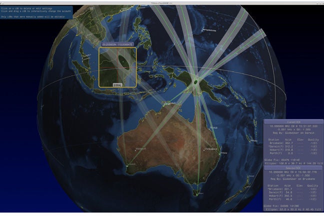
tsGlobe
Interactive 3D map/globe interface to display teamSENTINEL metadata results over high resolution Open Street Map geospatial data.
For HF/DF-enabled SIGINT sensors, teamSOIGNE’s tsGlobe application provides an interactive 3D map/globe interface to display OpenStreetMap® geospatial data. Lines of bearing (LOBs) and computed geo-fix results are interactively linked from the SOI shown in tsSpectrum to the tsGlobe 3D viewport. The tsGlobe display can be independently manipulated to allow analysts to pan/zoom, change display parameters, such as points of interest and political boundaries, and make measurements.
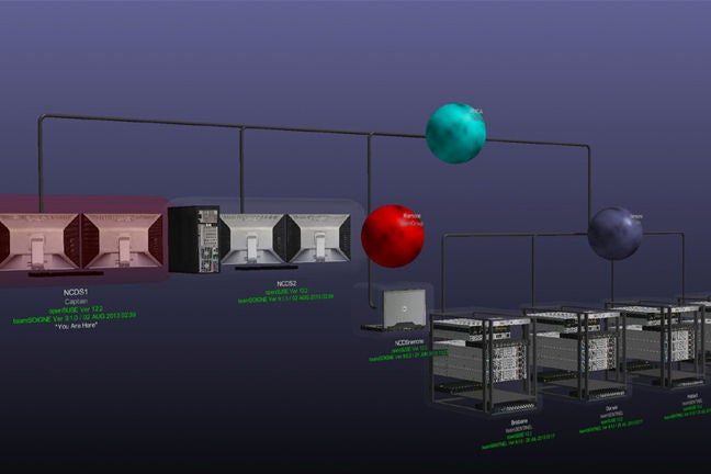
tsAdmin and tsControl
Monitor all the vital operational parameters of all teamSENTINEL sensors configured to your operational domain
TeamSOIGNE’s tsAdmin application provides a interactive 3-dimensional graphical interface for provisioning, monitoring and control of networks of local and remote teamSENTINEL sensors. Using tsAdmin, a sysadmin can administer individual teamSOIGNE clients and teamSENTINEL sensors, and the operational relationships (access) between and among sensors and clients. Click on the module of interest, and drill in to monitor that component, view log files, or interactivly reconfigure the the module or sensor.
Using tsControl, operators and system administrators alike can monitor all the vital operational parameters of all teamSENTINEL sensors configured to their operational domain including:
- System uptime
- Recorded data life
- Tuner channel sample rates
- Number of virtual channels
- Channel CF and bandwith
- Gain/attenuation and power
- Instantaneous power spectrum
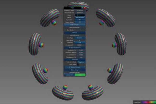
tsArrayEditor
Interactive 3D map/globe interface to display teamSENTINEL metadata results over high resolution Open Street Map geospatial data.
tsArrayEditor is a unique graphical tool used to visualize DF array manifold files and display the performance of individual array elements. This provides the ability to create array manifolds based on the antenna geometry and other characteristics, which can then be used to configure a DF sensor to provide accurate DF. This greatly reduces the cost of creating these manifolds.
Highlights
Edge Sensors and Processing:
Integrates COTS equipment around system software to develop higher quality sensor data that discovers, identifies, records, and remembers.
Network:
Creates teamVIEW (sensor data displayed allowing operators to view sensor data from all or select sensors in the worldwide network).
RF/ML classification:
Leverages spectral imaging as the basis for RF/ML integration; allows operators to be more engaged and continually enhance the confidence scoring.
Streamlined RF/ML training:
Intuitive GUI allows operators (vs. engineers) to create new models with < 2 hrs to train.
Precision Geo-Location:
JICD 4.2 compliant AOA/TDOA algorithms provide precision geolocation.
Data Analytics:
Collects and records meta data allowing web-based browser views for rapid data analysis
Improved Workflows:
Integrates the spectral, globe and image processing views allowing operators to quickly mine spectrum for signals of interest.
Enhanced Visualization:
Utilizes spectral imaging and mapping allowing operators to make sense of the RF environment with limited radio protocol expertise.
Applications
Signals Intelligence:
teamSENTINEL solutions provided through integrating RF/ML, Geolocation and Visualization tools to enable signal analysts to discover and analyze signals of interest in an ever-changing RF environment across a national network of sensors.
RF Battlefield Visualization:
Interference, both intended and unintended, from electromagnetic emissions can disrupt battlefield operations. teamSENTINEL sensors allow operators to understand what the digital battlefield signature looks like and safeguard locations and troop movements from compromise and prevent inadvertent interference with allied force equipment.
Warfighter Threat Detection:
Whether tethered or untethered, teamSENTINEL systems visualize the immediate location so warfighters can immediately identify new emissions in their surrounding area. Geolocating these emitters allows for situational awareness on the battlefield.
Border Monitoring:
Organized criminal organizations take advantage of the ease of movement across borders and continue to develop methods to evade detection. Deploying teamSENTINEL with geofencing capabilities allows border patrol organizations to understand the RF environment and locate these illicit operations.
Spectrum Monitoring:
Understanding the RF environment to ensure the legal use by commercial and military organizations is important to maintain communication networks are properly functioning. teamSENTINEL offers 24/7 coverage of the RF spectrum, identification and location of emitters that threaten these networks.
Case Studies & Innovation Stories

The Mission
NASA’s James Webb Space Telescope will capture images and spectra that will help us understand how today’s universe emerged.
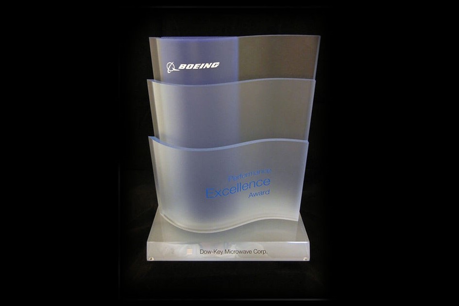
MPG Receives Boeing Performance Excellence Award
Dow-Key® Microwave was selected by Boeing to receive the Boeing Performance Excellence Award. This is their third time receiving the award.

P-8A Poseidon Mission
MPG equipment delivered on the goal of Connecting and Protecting People by providing clear communicatins over long distances in this search and rescue (SAR) event.
Resources

teamSENTINEL Nano Gen2 Factsheet

TeamSOIGNE Products Datasheet

RF Multicoupler Solutions Datasheet

VUHF-Toadstool Gen2 Antenna Datasheet
Contact
Subscribe to receive all MPG updates.
SUBSCRIBE
REACH US AT
Microwave Products Group
13033 Trautwein Road
Austin, TX 78737
United States
Main: 410-749-2424
support@mpgdover.com
© COPYRIGHT ©2026, MPG - MICROWAVE PRODUCTS GROUP | A DOVER COMPANY | PRIVACY POLICY | COOKIES | TERMS OF USE